


DOCUMENT
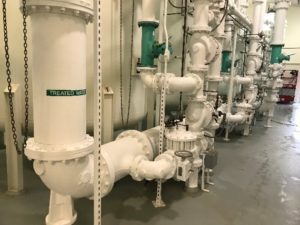
Located 65 miles outside of Chicago, the City of Dekalb’s five water treatment plants and three storage tanks serve drinking water to over 45,000 local residents. While their water department had successfully ran a GIS program for their linear street assets (valves, hydrants, mains, etc.), they had no asset information attributed for the vertical assets inside their water treatment facilities. After being introduced at an Esri event, Dekalb knew LandTech Consultants was the partner to help them enrich their asset management and field operations.
“Prior to working with LandTech, identifying individual assets inside of the facility was extremely difficult.” – Justin Netzer, Utility Superintendent, City of Dekalb
DESIGN
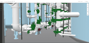
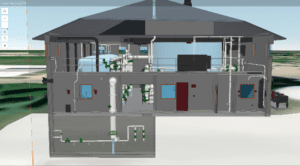
The project design goal was to ensure both onsite and offsite field crews would have access to individual asset locations, mark-ups, technical maintenance data and history, and other asset records. First, a LIDAR Survey was performed to capture the existing conditions of the facilities in a processed 3D point cloud. From the point cloud, a BIM model was created to LOD 350 standards. Fully attributed with their asset management records, a virtual digital twin was created, providing the visual interface needed to relay asset information to both field and office personnel. The digital twin was incorporated into the GIS geodatabase and online feature services utilizing ArcGIS Online. The model was deployed in the field through ArcGIS Companion and ArcGIS Earth to relay the asset location and information to the field. Along with the model, a Survey123 form was also deployed for the field, so accurate maintenance and work order records could be maintained.
DEVELOP
LandTech has completed two of the five water treatment plant projects to-date. After seeing such project success, the City of Dekalb is partnering with LandTech to scale the solution system-wide. Modeling and integration of the three additional water treatment facilities was completed in 2022.
“The 3D GIS models LandTech provided were extremely valuable to our organization and workflow. With one click I can see what the asset is and who I need to contact for different parts. The field technicians on-site have access to the same data set, in real-time and while onsite. We plan on working with LandTech to expand this program to other facilities.” – Justin Netzer, Utility Superintendent, City of Dekalb
WATCH THE DEMO
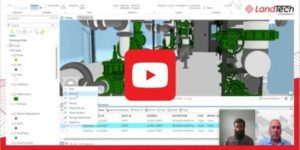 In this 2-minute clip, see how the GIS-Digital Twin integration improves vertical asset management. Perform work orders, tasks, order replacement parts, view the 3D GIS model, and more – all able to be viewed directly in their Maximo enterprise asset management platform. Want to take a deeper dive? Watch our recent 30-minute Digital Twins webinar, featuring the Dekalb Water Treatment Plant projects.