


CREATE
The Little Patuxent Water Reclamation Plant treats wastewater for over 150,000 residents in Howard County. The county wanted a comprehensive solution to improve their asset management and field operation workflows. In partnership with Gannett Fleming, LandTech Consultants presented Howard County with an Esri ArcGIS solution to solve their challenges and an agreement was reached to launch a pilot project to evaluate the proposed solution for one of Howard County’s pipe gallery facilities.
INNOVATE
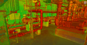
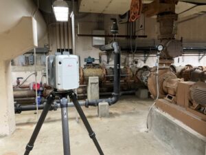
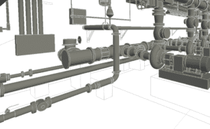
Howard County chose their lower pipe gallery for this pilot project due to the complexity of the system and the variety of assets. LandTech performed a LIDAR survey to capture the facility’s interior and exterior, then linked the scans to the facility’s established site control to localize the data to the coordinate system used by the county. From the point cloud, LandTech produced a BIM model to LOD 350 that included system information for each of the elements from record data and information collected on-site. The BIM model was converted into an Esri geodatabase for use in the Esri environment and the digital twin was published to ArcGIS Online for viewing throughout the organization. The deliverables included a point cloud, BIM model, and a 3D Esri geodatabase (or digital twin).
INTEGRATE
Howard County was impressed with the digital twin solution and the enterprise-wide value it provided as a central digital repository that’s accessible in the office or remotely. They plan to create a digital twin for their entire facility and integrate it with their asset management platform in the near future. Additionally, they are looking to integrate their campus’ horizontal assets with these 3D models to give a holistic view of all their assets both inside their facilities and the subsurface utilities.
Download Little Patuxent Water Reclamation Plant Case Study PDF