


 CHALLENGE
The University of Denver (DU) Facilities Management and Planning (FMP) department oversees more than 100 buildings and 4 million square feet of space across its campuses. As an R1 research institution, DU needed a modern, centralized platform to manage its facilities, improve space utilization, and streamline reporting for sponsored research programs. The university sought to replace disparate systems and manual processes with a unified, location-aware solution that would enhance transparency, accuracy, and accessibility of facility data across departments. After evaluating multiple options, DU selected ArcGIS Indoors for its scalability, integration capabilities, and alignment with DU’s existing ArcGIS ecosystem.
 SOLUTION
 SOLUTION
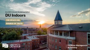
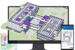
DU partnered with LandTech, a leader in ArcGIS Indoors implementation and spatial data management, to guide the project from concept through deployment. LandTech first launched a four-building pilot that validated workflows and informed the configuration of a campus-wide rollout encompassing 100 facilities. The project included standardizing CAD and Revit data, designing a robust Indoors Information Model, and developing a suite of custom applications for space planning, grant and functional allocation, change requests, reporting, and risk management. Tools such as Building Viewer, Indoors Viewer, and Space Planner now provide intuitive access to real-time building and room data, while the Change Request Suite and integrated dashboards streamline updates and approvals. Collaboration and stakeholder input were central throughout, ensuring the solution met operational, financial, and research requirements.
RESULT
 RESULT
The implementation has already transformed DU’s approach to space management. Staff now have a single source of truth for campus facilities, improving operational efficiency, data accuracy, and decision-making across all departments. Automated quality checks, integrated reporting, and mobile accessibility enable proactive management of grants, space utilization, and building assets. As DU looks ahead, planned integrations with Banner and TMS, expanded analytics, and continued onboarding of new facilities will further strengthen this digital foundation. DU’s collaboration with LandTech demonstrates how ArcGIS Indoors empowers large institutions to make data-driven, location-aware decisions that support research excellence and long-term campus growth.
DU’s collaboration with LandTech highlights the power of ArcGIS Indoors for large-scale facility management. As the project moves towards completion, it stands to significantly improve DU’s space management capabilities, supporting their esteemed research programs and operational needs with cutting-edge technology.
Read the StoryMap to learn more about this project.
Learn More
 Learn More
Is ArcGIS Indoors the right solution for your facility management needs? Connect with the experts at LandTech to schedule a virtual meeting and demo!