


 Building renovations or additions currently make up the majority of architectural projects. Healthcare, educational, commercial, industrial and even residential development more often than not now includes some type of renovation to an existing structure. With over 70% of construction falling into this category it is more imperative than ever architectural offices get off to the right start. Before the design process can begin the need for an accurate existing conditions survey exists. If the building to be renovated is square or rectangular, repetitive in design elements and has an interior finish level that is either being demolished or simply leaves much to the imagination than there are several options available for obtaining these dimensions. From a single shot laser meter to an old fashioned tape measure you may be able to quickly obtain the information you need at an accuracy level you can accept.
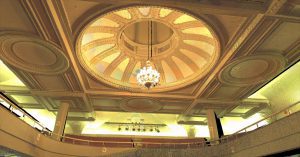
But how do you obtain accurate measurements when the dimensions you need are “out” of the box? Older structures that are being renovated often contain elements that contain unique architectural elements and shapes, finely detailed craftsmanship and structural components not often utilized in today’s designs. The need to replicate finish details, match complex elements at critical junctions and check for cantor or plum often come into play. Coupled with extensive MEP, suddenly the task of architectural documentation with a single shot laser or tape measure appears daunting. These are the tasks 3D laser scanners are meant for.
Utilizing a 3D laser scanner these out of the box elements are quickly and accurately documented to a level not previously obtainable. Where a single shot laser meter may obtain one or two shots on an element for location, a 3D laser scanner can capture as many as 1 million shots per second. The resulting point cloud essentially paints a picture of the located elements and documents extensive details otherwise unobtainable. The point cloud can then be utilized to create a 3D existing conditions BIM model in numerous software packages for further review and design. When multiple scans are registered and processed properly the resulting model is at the highest levels of accuracy. Several BIM software packages (in particular Revit) have now been optimized to allow direct import of laser scanning point clouds, allowing the user to virtually see the documented items. The resulting point cloud “picture” allows for virtual measurements to be taken directly from elements. Everything that was in the field of view of the scanner at the point of the scan is available for measurement, all but eliminating repeat trips. In many cases the need for creation of an existing conditions or as-built BIM model is not necessary as the point cloud itself acts as the model and can be inserted directly into the design model, quickly identifying conflicts and trouble areas.
Have a project where only portions need the accuracy of laser scanning? Utilization of multiple techniques can often provide the desired results at the most efficient cost. LandTech recently completed a two building project involving highly complex architectural and mechanical areas combined with simple square classrooms. A combination of the two techniques provided the client with the detail needed at the most cost effective price.
As with any task, the accuracy of the end results are only as good as the care that is taken in collecting and processing the data. Utilization of a firm highly trained in the use of laser scanners is recommended. Larger projects often require the services of a land surveying company that utilizes traditional survey technology to assure the highest accuracy in the processed data.
If your renovation project only involves the need to document simple and repetitive elements that are reasonably obtainable, utilize one of the traditional measurement technologies available. But if you require documentation to a high degree of accuracy, detailing integrated and complex elements in short order with very tight tolerances, consider 3D laser scanning. The time and money you save will far exceed the time and money you spend.
LandTech Consultants, Inc. is a full service Civil Engineering and Land Surveying firm highly immersed in 3D technologies for the A/E/C industries. We provide full 3D Laser Scanning and Modeling services for building documentation in multiple formats. Contact us today to discuss your project.