


We know that 3D modeling in the building design and construction world is gaining steam and has been shown to substantially cut construction costs and decrease construction time. But how can 3D modeling be useful with pushing dirt and installing site utilities? Well, just as impressive as BIM, is 3D machine control modeling.
 Just as many architects now utilize BIM and the many advantages it has in design and construction of buildings, civil engineers have the design tools available to design sites in 3D as well. Software packages such as AutoCAD Civil 3D allow engineers to design site grading, drainage and utilities in the 3D world, thereby allowing for quick conflict resolution with underground infrastructure as well easy calculations for quantity takeoffs on materials. Balanced cut and fill sites are easily attainable utilizing quick commands. Want to know how a building foundation will interact with existing or proposed subsurface utilities? A few simple clicks will give you the answers. But where does the site model come into play with the actual site construction?
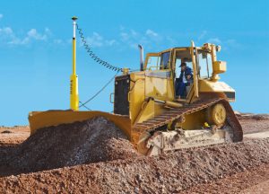
Several of the leading site contractors now utilize 3D machine control for large or complex site designs. Simply put, bulldozers, excavators and backhoes are equipped with on-board computers. The blades and buckets are also equipped with GPS devices. Either a GPS base station is set up on the individual site or the site contractor subscribes to a regional GPS service, either of which communicates with the GPS receiver on the individual piece of equipment to precisely find where on the site the equipment is located. If the site design has been prepared utilizing 3D design software, the site design can be transformed into a 3D model that can be loaded onto the onboard heavy equipment computer. Even if the site has not been designed in 3D, the 2D design plans can still be utilized to create a 3D model relatively quickly.
Once the model has been created it is referenced to the site GPS co-ordinates and loaded onto the site equipment computers. The computers are linked to the GPS receivers and the equipment controls. As the equipment moves through the site the GPS records exactly where it is and the computer records exactly where within the model the equipment sits. Depending on the type of equipment and the function you are looking to achieve, the dozer blade and the excavator bucket will automatically respond to the model and adjust to the required surface elevation or the depth of excavation. Grading of roads, parking lots, sidewalks or utility trenching and infrastructure placement has never been easier and more accurate than with machine control and the use of 3D models.
In addition to site grading and utilities, model elements may include curbing, fire hydrants, landscaping, park benches and virtually any other element that may have been part of the site design. These elements are now all entered into the GPS site control for exact location and installation in accordance with the approved design. The end result: a site built to the requirements of the design with minimal input for error.
Obviously this is a simplified description of how it works but the benefits are every bit as real as those of BIM. Cost savings and decrease of construction time are immediately evident. Construction in real time with real savings.
LandTech Consultants provided detailed machine control modeling for the recently opened Market Street complex in Lynnfield, MA. A 100+ acre site, the mixed use development incorporates an upscale urban streetscape in a combination of retail, office, residential and park settings.